Satellite technology for territorial and risk management
So what happens when you see the city literally from above. Urban planning gets easier. Right? This is what has been happening in my country during last year and I'm about to tell you how :)
Satellites (in 2 minutes)
There are different types of satellites, these are:
- Communications satellites, whose purpose is to link telecommunications between different parts of the planet, ensuring services such as television, telephony or internet.
- Global navigation satellites, which transmit signals to terrestrial devices to determine positions (such as GPS).
- Meteorological satellites, used to record weather forecasts and create Earth's climate models.
- Earth observation satellites, category to which PeruSAT-1 (our satellite) belongs, whose objective is to take and send images of the territory while orbiting the planet (CONIDA, parr. 3-4, 2018).
The PerúSAT-1

Satellite images in post-disaster reconstruction
Bye,
Flavio 🌆
It is the most powerful Earth observation satellite in our region, operated by the Peruvian Space Agency (CONIDA), that travels 14 pre-established orbits daily (circling the earth 14 times) at a speed of 7.5 km/second running on solar energy . Its main objective is the collection of free access satellite images for government entities, companies and civil society. In this link (spanish alert!) you can find a more complete infographic about your work process and results.
Before our Ministry of Environment had to obtain these satellite images through cooperation with other governments such as Japan (MINAM, par. 1, 2013). Currently, since the launch of our Peruvian satellite in December 2016, more than 100,000 high-resolution images have been acquired and they have been used by 130 public entities. (CONIDA, par. 5, 2018). These are requested by the users of these entities (Agencia de Noticias Andina, 2018) and some projects for which they have been used are:
- Office of the Public Prosecutor, to detect irregularities in public works.
- Peruvian National Police, to verify properties where drugs are trafficked.
- San Martín Region, to generate identification maps of deforested areas.
- Civil Defense National Institute (INDECI), to plan responses to natural disasters.
- National Geographic Institute, to generate national cartography at 1: 25000 scale (CONIDA, par. 5, 2017).
- National Superintendence of State Assets, to supervise public works.
- Ministry of Education, to know areas where schools will be built.
- Peruvian Navy, to observe the presence of foreign vessels in the Peruvian sea (Mendoza, 2018).
- Ministry of Energy and Mines, to monitor volcanoes, river channels and earth movements.
- National Water Authority, to study changes in glaciers (RPP, parr, 4-8, 2018).
- Preparation of rural-urban cadastre (Agencia de Noticias Andina, 2018).
- Development of ecological-economic zoning (MINAM, parr. 4, 2018).
Satellite images of PerúSAT-1
Huacachina, Ica

Puerto de Paita, Piura
 |
| Source: (Mendoza, 2018) |
Satellite images in post-disaster reconstruction
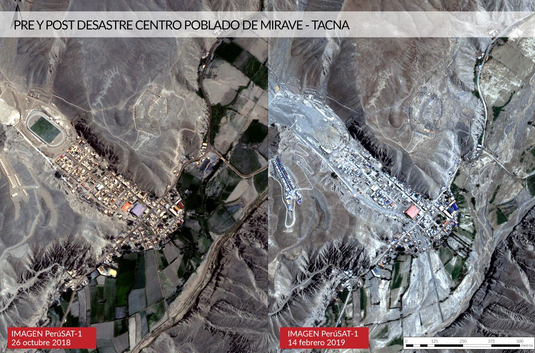
By having satellite images of the Peruvian (or foreign) territory constantly updated, there is the opportunity to observe where people should not live after natural disasters by being able to identify almost in real time the areas where floods, landslides, mudslides or emergencies happen. For example, in these two images of Moquegua and Tacna you can see the pre and post natural disaster images that occurred in southern Peru during last month.
Satellite images pre and post disaster of Moquegua and Tacna
 |
| Source: (CONIDA, 2019) |
 |
| Source: (Andina, 2019) |
In the images we can see that public infrastructures such as the bridge or the stadium have been damaged by mudslides, not to mention the affected houses, victims and lost lives. Our National Disaster Risk Management System emphasizes that reconstruction to restore sustainable development conditions in affected areas is a priority. With PeruSAT-1 we can make better decisions in order to protect human lives and public investment.
Finally, it has also been used by San Marcos University, INDECI and UNDP in the DIPECHO program to generate post-disaster recovery tools and scenarios for Lima and Callao in the event of earthquakes, tsunamis and floods (CONIDA, 2018; PNUD, 2019).
Probably a few years ago no one thought that we could use satellites to plan our cities. That leads me to wonder what other technologies currently not used in the urban environment will be used in the planning of the built environment in the future?
Bye,
Flavio 🌆


Comments
Post a Comment